TAMPA, Fla. — Washington-based Hydrosat, a geospatial data and analytics startup, announced July 29 it has secured U.S. regulatory approval to provide global services from its upcoming thermal imaging system.
Hydrosat was awarded a National Oceanographic and Atmospheric Administration license at Tier 1, which has the fewest conditions under a streamlined regulatory regime that came into effect in 2020.
Tier 1 systems have capabilities deemed “substantially the same” as foreign commercial systems and others that are also not licensed by the U.S. Commerce Department.
Tier 2 remote sensing ventures offering data matched only by other U.S. systems, and Tier 3 systems seeking to provide a “completely novel capability,” are subject to stricter regulatory constraints.
Hydrosat CEO Pieter Fossel said Tier 1 certification gives the startup the highest degree of flexibility in how it can collect and sell data commercially.
The license “gives us the most freedom to operate independently, and signifies that NOAA has determined that what we’re doing as a commercial organization, as an exporter, as a job creator is worthwhile,” Fossel said.
VanZyl-1, Hydrosat’s first satellite mission, is set to launch on a Loft Orbital condosat via a SpaceX Falcon 9 rideshare mission early next year.
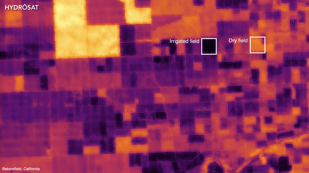
The payload will use multi-spectral infrared sensor technology to track water stress, assess wildfire risk and support agricultural monitoring applications.
Hydrosat ultimately plans a constellation of about 16 satellites, which Fossel said would enable it to “image every spot on Earth twice per day.”
Combined with in-house analysis, Hydrosat says its surface temperature data enables a variety of geospatial intelligence solutions, including services for helping farmers understand local crop conditions and supply.
The startup raised $10 million in seed funding last year, bringing total funding for its goal to develop global thermal infrared maps to $15 million.
Other startups developing thermal imagery satellite constellations include U.K.-based Satellite Vu and Germany’s OroraTech.
OroraTech deployed its first satellite, FOREST-1, in January and is focused on monitoring wildfires.
Satellite Vu, which expects its first satellite will be launched in the first quarter of 2023, specializes in tracking heat waste from buildings for climate change applications.
The British startup said July 21 it has ordered a second satellite that is slated to launch in early 2024.